Colin A. Zelt
Department of Geology and Geophysics, Rice University
P.O. Box 1892, Houston, Texas, 77251-1892, USA
Geophysical Journal International, 135, 1101-1112, 1998.
A method for estimating the lateral velocity resolution from 3-D seismic refraction traveltimes is presented. The method is nonlinear in that synthetic data calculated from "checkerboard" models are inverted using an iterative tomographic approach incorporating smoothness constraints and updated raypaths at each iteration. Two applications are presented: (1) the real data from the Faeroe Basin experiment using the ray coverage and noise level of the ~50,000 picks, and (2) the ideal data from the same experiment corresponding to 100% data recovery, equivalent to about three times as many raypaths. The refraction data constrain the sedimentary and basement structure to ~12 km depth. A comparison of the results from the two data sets provides a qualitative check on the resolution method, illustrates the pitfalls of using ray coverage as an indicator of resolution, and demonstrates the potential resolution of currently feasible 3-D refraction experiments. Thirty- two checkerboard models consisting of alternating positive and negative velocity anomalies superimposed on the preferred final model of the basin were tested, each with a different cell size, position or orientation. The problem of ray bending associated with the 5% checkerboard anomalies is shown to be small. Using models with four cell sizes allowed for resolution estimates from 3 to 15 km, this range being imposed by the frequency content of the data and the areal dimensions of the study area (44x26 km). An operator centered on each model node measures the local semblance between the known and recovered checkerboard models. A determination of the smallest well-resolved cell size at each model node is then made using a 0.7 semblance threshold to provide a spatially-dependent lateral resolution estimate. Resolution for the real data set varies from an average of just over 3 km at 2 km depth, to 10 km at 10 km depth, where there is a local maxima in ray coverage due to a concentration of ray bottoming points. For the ideal data set, the average lateral resolution drops off roughly linearly from better than 3 km at 2 km depth, to 6.3 km at 10 km depth. The largest difference between the ideal and real data's resolution occurs at 7.2 km depth where it averages 4.6 km for the former and 10.8 km for the latter due to the near absence of ray bottoming points between 7 and 9 km. The results show that the final model for the Faeroe Basin obtained by regularized inversion with smoothness constraints is consistent with the resolution estimates in the sense that the model does not contain structure with a wavelength smaller than the resolution estimate at any point. The results for the ideal data show that good quality 3-D refraction experiments can provide a lateral resolution of no worse than the receiver spacing (shot spacing for land data) throughout most of the sampled volume.
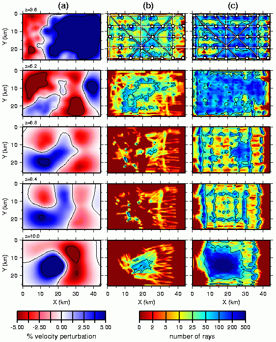
(a) 3-D Faeroe Basin velocity model (Zelt and Barton, 1998) shown as relative perturbations with respect to the laterally homogeneous background model for depth slices at 3.6, 5.2, 6.8, 8.4, and 10 km as labeled. The contours correspond to -5%, 0, and +5%, respectively. (b) Ray coverage corresponding to the depth slices shown in (a) for the real data set. (c) Ray coverage corresponding to the depth slices shown in (a) for the ideal data set. The OBS locations (open circles) and shot lines for the real and ideal data sets are superimposed on the z=3.6 km slices in (b) and (c). The ray coverage is calculated using a 0.4x0.4x0.4 km cell size. The level 50 contour is shown.
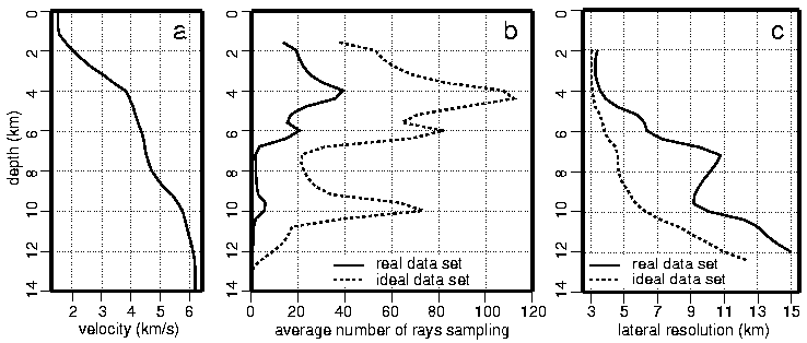
(a) 1-D (lateral average) of the 3-D Faeroe Basin velocity model. (b) The average number of rays sampling each node as a function depth for the real and ideal data sets. (c) The average lateral velocity resolution as a function of depth for the real and ideal data sets.
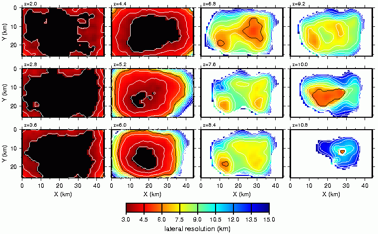
The lateral resolution of velocity is contoured from 3 to 15 km corresponding to the ray coverage and noise associated with the real 3D seismic refraction data from the Faeroe Basin experiment (Zelt and Barton, 1998). Black indicates regions with better than 3 km lateral resolution; white indicates regions with worse than 15 km lateral resolution. For reference, the 6 km contour is black (note: OBS spacing is 6 km).
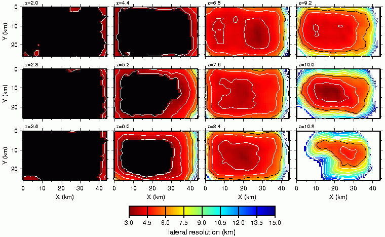
Same plot as above, except assuming there had been 100% recovery of all OBSs and all shots into all OBSs could be picked.