Colin A. Zelt
Department of Geology and Geophysics, Rice University
P.O. Box 1892, Houston, Texas, 77251-1892, USA
Zelt, C. A., A. M. Hojka, E. R. Flueh, and K. D. McIntosh, 3D simultaneous seismic refraction and reflection tomography of wide-angle data from the central Chilean margin, Geophys. Res. Lett., 26, 2577-2580, 1999.
We present the first known application of three-dimensional (3D) simultaneous seismic refraction and reflection tomography for velocity and interface structure. The inversion technique and method for developing a suitable starting model are specifically designed for relatively sparse wide-angle data acquired across strongly-varying earth structure. The data were recorded in a region of seamount subduction on the central Chilean margin and consist of seven ocean bottom hydrophones and ten intersecting airgun profiles over a 90x90 km area allowing imaging to about 25 km depth. The tomographic method and the final model are assessed through a comparison with the large-scale geologic features of the margin and a checkerboard resolution test. The 3D model shows the Valparaiso forearc basin, the accretionary wedge, the Punta Salinas Ridge, the backstop, the subducting oceanic crust and Moho, and possibly the top of a subducted seamount. Our results show the potential of relatively sparse 3D wide-angle data that may result from poor data recovery, limited resources, or a primarily 2D survey.
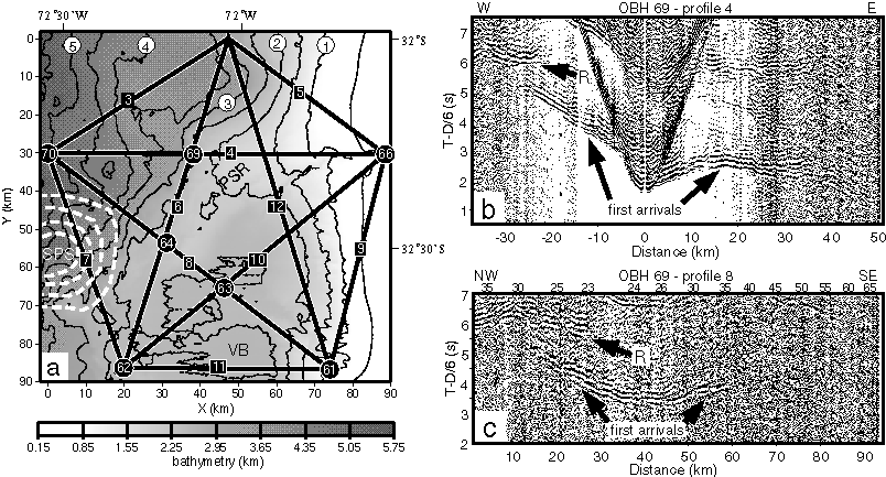
Figure 1. Experimental geometry and data examples. (a) Numbers from 61 to 70 in circles are OBH locations and numbers from 3 to 12 in squares identify the ten airgun profiles shown as thick black lines. Bathymetry is shaded and contoured; contour interval is 0.5 km; contours 1, 2, 3, 4, and 5 are labeled by numbers in white circles near the top. Dashed white lines are magnetic contours identifying the subducted Papudo seamount (SPS). PSR - Punta Salinas Ridge, VB - Valparaiso Basin. Model x and y coordinates and latitude and longitude are labeled on the sides. (b) In-line data example recorded at OBH 69 from shots along profile 4. Data reduced using 6 km/s and bandpass filtered from 2 to 15 Hz. Horizontal scale is source-receiver offset. First arrivals and reflections from the oceanic Moho (R) indicated. West and east profile direction indicated at the top. (c) Off-line data example recorded at OBH 69 from shots along profile 8. Horizontal scale is distance from NW end of profile 8; source-receiver offset indicated above data. Other details as in (b).
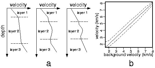
Figure 2. Two aspects of tomographic method. (a) Velocities are "tied" to the interfaces. The velocity and interface structure is shown for a single column in the 3D model before an inversion (left), after updating the velocities (middle), and after updating the interfaces (right). The shape of the velocity increase in layer 2 is "compressed" after adjusting the velocity-depth structure to account for the updated interface depths. (b) The velocity at each node in the 3D model is bounded to fit between the dashed lines depending on the velocity in the starting/background model by clipping the velocities after each iteration.
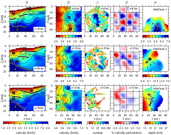
Figure 3. 3D P-wave velocity and interface model with ray coverage and results of resolution test. (a) Three vertical and (b) three horizontal slices through the model at the y and z positions indicated. Portions of the interfaces constrained by reflection points within 20 km of each y slice indicated by thick black lines; interface 1 is not constrained near y=30 km. Contours correspond to the divisions of the color scale bar; different scales are used for each horizontal slice. Vertical exaggeration is 2.5:1 in (a). (c) Ray coverage corresponding to the slices in (b) using a 2x2x0.5 km cell size. (d) Results of a checkerboard resolution test corresponding to the slices in (b) using a 23 km cell size as indicated by grid lines, and 5% velocity anomalies. (e) Three interfaces with reflection points indicated by black dots; only portions of interfaces within 20 km of a reflection point are shown. Interface 1 - base of Valparaiso Basin, interface 2 - base of accretionary wedge, interface 3 - oceanic Moho. Circled numbers in (a), (b) and (e) indicate large-scale geologic features: 1 - slope sediments, 2 - accretionary wedge, 3 - Valparaiso Basin, 4 - Punta Salinas Ridge, 5 - subducted oceanic crust, 6 - oceanic mantle, 7 - subducted Papudo seamount.