Crust and upper mantle structure interpreted from wide-angle seismic data along a 260-km profile across the Central Metasedimentary Belt of the southern Grenville Province in Ontario and New York state shows (i) relatively high average crustal and uppermost mantle velocities of 6.8 and 8.3 km/s, (ii) east-dipping reflectors extending to 24 km depth in the Central Metasedimentary Belt, (iii) weak lateral velocity variations beneath 5 km, (iv) a mid-crustal boundary at 27 km depth, and (v) a depth to Moho of 43-46 km. The wide-angle model is generally consistent with the vertical-incidence reflectivity of an intersecting Lithoprobe reflection line. The mid-crustal boundary correlates with a crustal detachment zone in the Lithoprobe data and the depth extent of east-dipping wide-angle reflectors. Regional structure and aeromagnetic anomaly trends support the southwest continuity of Grenville terranes and their boundaries from the wide-angle profile to two reflection lines in Lake Ontario. A zone of wide-angle reflectors with an average apparent eastward dip of 13 degrees has a surface projection that correlates spatially with the boundary between the Elzevir and Frontenac terranes of the Central Metasedimentary Belt and resembles reflection images of a crustal-scale shear zone beneath Lake Ontario. A high-velocity upper-crustal anomaly beneath the Elzevir-Frontenac boundary zone is positioned in the hanging wall associated with the concentrated zone of wide-angle reflectors. The high-velocity anomaly is coincident with a gravity high and increased metamorphic grade suggesting northwest transport of mid-crustal rocks by thrust faulting consistent with the mapped geology. The seismic data suggest (i) a reflective, crustal-scale structure has accommodated northwest-directed tectonic transport within the Central Metasedimentary Belt, (ii) this structure continues southwest from the exposed Central Metasedimentary Belt to at least southern Lake Ontario, and (iii) crustal reflectivity and complexity within the eastern Central Metasedimentary Belt is similar to that observed at the Grenville Front and the western Central Metasedimentary Belt boundary.
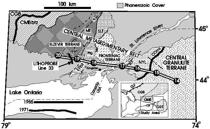
Figure 1. Location map. Shots points (numbered 20-14) and receiver sites of the wide-angle profile are indicated. Lithoprobe reflection line 33 (White et al., 1994) and the 1971 and 1985 Lake Ontario reflection lines (Forsyth et al., 1994) are also indicated; the final stacks of these lines are shown in Figs. 3, 4 and 5. The dashed line labelled `M' extending northeast from shot point 20 is line BO of Mereu et al. (1986); the line crossing the CCmz labelled `C' is line 8 of Klemperer et al. (1985). The inset shows the location of the study area with respect to the Grenville Front (GF) to the northwest. CGB= Central Gneiss belt, CMB = Central Metasedimentary Belt, CGT = Central Granulite Terrane, CMBbtz = CMB boundary tectonic zone, CCmz = Carthage-Colton mylonite zone, MT = Mazinaw terrane, SLT = Sharbot Lake terrane, NYL = New York Lowlands, EFbz = Elzevir-Frontenac boundary zone, CRs = Clare River structure, RLmz = Robertson Lake mylonite zone, Hg = Hinchinbrooke gneiss, Msz = Maberly shear zone, BCf = Black Creek fault.
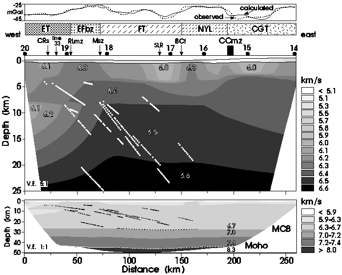
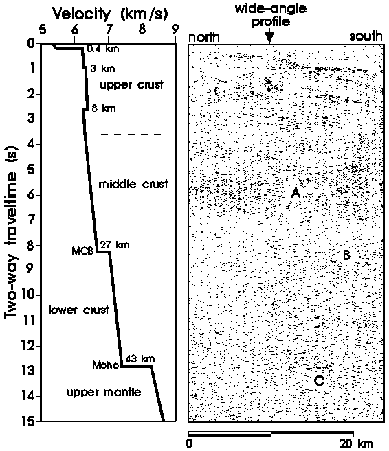
Figure 2.
Final velocity model.
Vertical exaggeration is 5:1 for upper- and mid-crustal model above
and 1:1 for complete model below.
Contoured velocity field is presented, omitting
the perimeter not constrained by the wide-angle data.
Numbers inside models indicate P-wave velocity in km/s.
Upper crustal boundary at the base of the surface layer is shown
in the upper model
and the mid-crustal boundary (MCB) and Moho are indicated only where imaged
by PcP and PmP ray paths, respectively, in the lower model.
Line style of the MCB and Moho
indicates the wide-angle reflectivity factor (WARF):
solid line - WARF>1; dashed line - 0.5
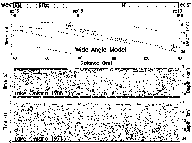
Figure 3.
Comparison of wide-angle velocity model and
Lithoprobe line 33 reflection data.
Location of the seismic lines indicated in Fig. 1.
Velocity function obtained from final wide-angle model
at intersection point with Lithoprobe line 33 (Fig. 2);
vertical scale converted to zero-offset two-way traveltime using
velocities from final model in Fig. 2.
Line 33 Lithoprobe reflection data are migrated and coherency filtered;
vertical exaggeration 1:1. Intersection point with wide-angle line
indicated by arrow at top; letters identify features discussed in the text;
two dots beneath arrow between 1-2 s
indicate the two-way time of two wide-angle reflectors at
intersection point with Lithoprobe line 33 (Fig. 2).
Figure 4.
Comparison of wide-angle reflectors and 1971 and 1985
Lake Ontario reflection data.
Location of the seismic lines indicated in Fig. 1.
Horizontal and vertical
scales are the same for each profile; vertical exaggeration
~1:1. Depths scales at right obtained using velocities from final
model in Fig. 2. Circled letters identify features discussed in the text.
Reflection points of ``floating" crustal reflectors imaged by
wide-angle data indicated by small black dots);
distance-scale relative to final model in Fig. 2;
Reflection data are unmigrated and coherency filtered.
Shot points of wide-angle survey (large black dots) and tectonic units
indicated at the top. ET = Elzevir terrane, FT = Frontenac terrane,
EFbz = Elzevir-Frontenac boundary zone.
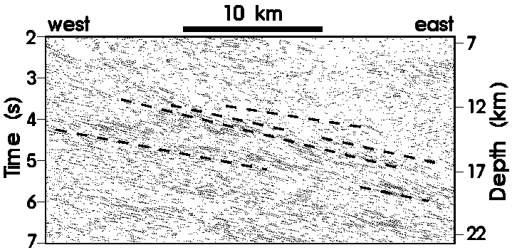
Figure 5.
Comparison of Lake Ontario reflection data and wide-angle reflectors.
The reflection line is ~130 km southwest of the wide-angle profile
along geological strike; the
wide-angle reflectors are projected onto the reflection line by
extrapolating the exposed geological features near the wide-angle
profile to Lake Ontario using the regional potential field data
[Forsyth et al., 1993]. The wide-angle reflectors are indicated by
dashed lines.
The depth scale on the right and the depth of the wide-angle reflectors
in zero-offset two-way time were obtained using the velocities of the final
model (vertical exaggeration ~1:1).
The set of wide-angle reflectors has been shifted vertically
downward ~3 km to account for along-strike variations in the depth
to the corresponding vertical-incidence reflection package.