A method for simultaneously inverting in-line seismic traveltime data recorded along a network of intersecting linear profiles is presented. Consistency of the models at the intersection points is assured and permits 3-D structural and velocity variations to be inferred by interpolation between the profiles. Common model parameters are used at the intersection points, thereby minimizing the number of independent model parameters and maximizing the degree of constraint of each 2-D model. The method has two main application: (1) to obtain the most constrained set of 2-D models for each profile if subsequent 3-D modelling is not possible, and (2) to provide a 3-D starting model for subsequent 3-D modelling if there is sufficient azimuthal data coverage. Some ideal line geometries are suggested, but the method is applicable to any set of two or more lines with one or more intersection point. A new interpretation of crustal seismic data from the Peace River Arch region of the Western Canada Sedimentary Basin consisting of four profiles is presented using the simultaneous inversion method for both refracted and reflected arrivals. The results are generally consistent with a previous interpretation of the data in which each profile was modelled independently of the others using 2-D forward modelling. However, the models obtained by inversion contain less lateral heterogeneity that more accurately reflects the resolution limits of the data. This illustrates the need to reconsider data that have only been analyzed by forward modelling.
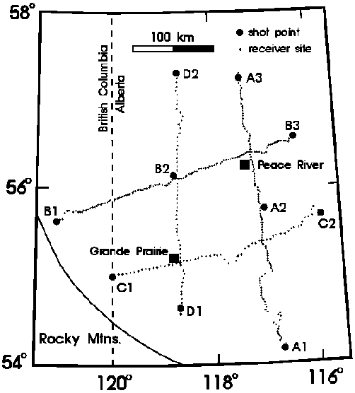
Figure 1. Location map for the Peace River Arch seismic experiment. The ten shots points and 336 receiver sites are indicated for each of the four profiles. The shot points labelled A1, A2 and A3 identify line A, and similarly for lines B, C and D. The Devonian axis of the Peace River Arch is approximately coincident with line B.
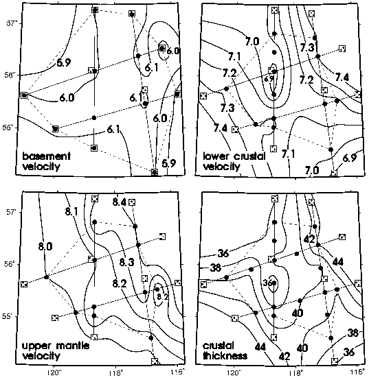
Figure 2. Basement, lower crustal and upper mantle velocity and crustal thickness in the Peace River Arch region as determined from the 2-D models for each line; basement refers to the top of the upper crustal layer beneath the sedimentary layers. Contour intervals are 0.1 km/s for velocity and 2 km for thickness. The straight lines and grey squares indicate the four seismic profiles and shot points (Fig. 1). The dots indicate the position of the nodes within the 2-D models representing the particular contoured parameter; note that for the basement velocity, there is a node coincident with the position of each end shot. Only the region enclosed by the dashed line is considered constrained by the seismic data.